What is an Exif, Anyway?

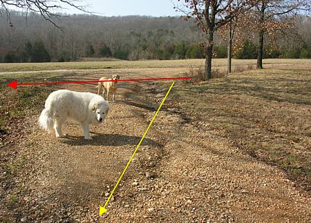
In a recent posting,  Pablo presented another fine article about that bit of land at the edge of the Ozarks that he calls Roundrock.  Within the post Pablo expressed uncertainty over the exact date that a photograph was taken.  With one mouse click, I was able to present Pablo with this needed information.

Of course, Tjilpi  (that rascal) noted that I might just have the power to reach into Pablo’s desktop to obtain that information.  If I did have that power, I promise that I would only use it for the good of mankind, but I must confess to much lesser degree of technical prowess than that.  Here’s the secret.  The Exif header.

For those of you who want to explore this thing called the Exif header in detail, this article from Wikipedia can point you in the right directions.  But here’s my nutshell explanation.

One of the powerful properties of a data file is the fact that many differing types of data can be stored together in the same place.  This creates some great opportunities when applied to the realm of digital image files.  When an exposure is made with a modern digital camera, the resulting image file that is created will contain 2 types of data – header data and image data.

The image data, as the term suggests, contains the specifications that define the actual image that we view, such as the picture that you see on a computer monitor, or the printed output from your color printer.

The header data, on the other hand, is an eclectic but useful combination of data relating to the image that it accompanies.  You might be surprised to learn how much information accompanies each digital image file, much of which can be put to good use by the photographer and his/her software. 

First, the basic camera settings at the time of exposure are included in the data.  This can be quite useful at times, for instance when Pablo needed to find the date a particular photograph was taken.  Along with the date and time, of course, the file includes a detailed record of parameters such as f-stop, shutter speed, ISO settings, metering mode, focus distance, flash mode, etc.  It is very useful to be able to review the camera settings when critiquing your photos.  You may discover which camera settings work for you, and which don’t under various photographic conditions.  Those of you with multiple digital cameras will appreciate that the Exif file records the camera make and model number, so you can identify which camera was used to produce any given photo.

Second, a thumbnail version of the full size image is usually stored in the Exif header.  This speeds up the operation of most modern image editing and viewing software, and provides a way for your camera to quickly display the image for review in the camera’s LCD monitor.

Third, the Exif header contains information that may be used to convey hardware dependent information along with the photograph, such as color matching hardware profiles.  While out of the scope of this post, the idea behind color matching is to provide a means whereby the image that is displayed on the screen, or output to the printer, will look the same.  For example, if you have a desktop computer with a CRT display and a laptop with a TFT or LCD display, you will soon discover that the same image file may look different when viewed side-by-side.  When set up and calibrated properly (a science onto itself), your hardware can be “trained” to display the images with a close match.  The information contained in the color matching profile, which can be included in the Exif header, is used as a part of this process.

Accessing Exif Information

Most image editing software has a means of showing the Exif header information.  Photoshop, for instance displays this information beneath the folder tree pane when a file is highlighted in the File Browser, or through a File-Properties menu selection.  Check you help file if you haven’t already figured out how to view this information in your own image editing software.

Windows XP and Mac OS10 x will also reveal Exif data from your image file.  For the Mac, Exif information may be viewed in the Finder by doing Get Info on a file and expanding the More Info section.  For Windows XP,  right-click on the image file and select Properties, then click on the Summary tab at the top.

For a stand alone program to examine Exif files, I use Exif Image Viewer, which is freeware available here.

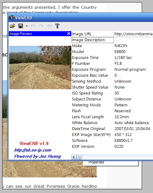
What I find most useful, however is to be able to easily examine the Exif header information for photographs that I am viewing in my web browser, such as the photograph that I saw at Roundrock Journal.   You can learn a lot from examining the Exif data of photos you find appealing.  For this application, I use a little gem of freeware called ViewEXIF, which is available here.  This installs itself as an extension to Internet Explorer or the Firefox browsers, and is simple to use.  Here’s how to do it.

1.  Download and install the software.

2.  From now on, when you right-click on any photograph displayed in your browser, you will see a screen like the following:

_________________________________________________

New Context Menu

_____________________________________________

You can see in the screen capture above that the Context Menu that pops up now has a new option – View EXIF.  Select this option, and the following window will immediately pop open:

Exif data listing from ViewEXIF

So there you have it – a quick and dirty primer on the Exif header file.  Now, learn to use these tools, and go forth wisely with your new found knowledge!

PS – Answer to the title of this post – Exchangeable Image File Format

What In the Heck Is This?

What town?

When gazing off toward the western horizon from the vantage point offered by our mountaintop (talk about making a mountain out of a molehill!), my eyes will usually come to rest at the location that is beneath the yellow arrow in the photograph displayed above.

Can you see what it is that I feel compelled to look at?

No?  It’s only 4.2 miles away, as the crow flies (which raises the question -what’s with that saying?  The crows I see around here never fly directly from one spot to another.  But I digress).

OK, OK.  I’ll show you a picture taken from the same spot, but at an earlier date and zoomed in to a larger magnification this time:

Here it is!

 Now you can see what is underneath the yellow arrow in the first photograph.  It is the town closest to our land, with a population of approximately 270 people.  It takes about 10 minutes to drive over to this little town from our house.  By contrast, it takes about 35 minutes to drive to the “city” closest to us (pop. 11,000+).

What might you find in our little town?  At one end sits a full-fledged post office facility, located next to a bank, where you can conduct some of your business.  Around the curve there are two diners, one of which serves only breakfast and lunch (their pies would probably win many county fair competitions).

Across the street are a couple of flea market type shops, perhaps with a rusty old 1949 Farmall C tractor in need of some TLC sitting out front.  There is a barber shop, a pizza shop, and a grassy parkway containing a small covered bandstand (donated and built by local volunteers).  The City Hall is located here, and it is open for business one day per week (I think on Mondays, but you might want to call ahead to be certain) .

The local telephone company maintains a small substation/maintenance office in town, and our volunteer fire department is housed in a nice facility in the center of town.  Further down the road, you will come to the town park, which is located next to the local Saddle Club facility, which includes a lighted riding arena, spectator stands, concession stand, and other equestrian facilities.  Who knows, maybe your neighbor might just be crowned Little Miss Rodeo Queen?

Little Miss Rodeo

As you continue down the road, you pass a couple of small businesses, including a new fitness center (a fitness center in a town of 270?)

The far end of town is where the local school district operates their only educational facility, serving grades K-12.  The district is tiny, with a total enrollment of 427 students in 2005.  Along the roadsides leading into town from both directions are the numerous churches which dot the landscape.

Now, finally, after all this lengthy babbling on about this little town, I get to the subject of this post, which is about where the true heart of this little community seems to centered.

Do you think that the heart of the community (H of C) resides at the school grounds?  After all, the school has athletic fields, a multi-purpose room, a new gymnasium, and is the place to be seen Friday nights during football season.  I don’t think so, because there are many empty-nesters and childless residents in the area.  They aren’t likely to be seen at school sponsored activities.

What about the churches?  Surely churches play a large part in the role of H of C out here, don’t they?  Well, yes and no.  Undoubtedly, a church provides a central role in the lives of area residents, especially in a bible belt region such as the Ozarks.  But because there are so many churches dispersed around this little town, each one only services a small fraction of the total population.  While serving an important function in the community, no single congregation can legitimately claim to be the H of C of this little town.

The Saddle Club, which hosts numerous events throughout the year, and is host to a great weekly “Family Fun” night during the warmer months, only serves the needs of the local equestrian community.  If you aren’t a horse person, you would have no reason to frequent this facility.

How about the local diners?  Doesn’t everybody eat out from time to time?  Couldn’t these places thus serve as the H of C?  Maybe, except that one diner is only open through lunchtime (the one with the great pies), and has a small dining room, thus could never serve as a crossroads for the town.  And the remaining diner, while providing a decent meal, is somewhat pricey for this neck of the woods, thereby limiting it’s potential to be the popular spot an H of C must be.

Rather than continuing to eliminate one candidate after another in my quest to arrive at the true heart of the community, I will cut to the chase and present my nomination:

The hub of the community

The Country Market.  Every small town aught to have a place like this in it’s midst.  More than just a spot where you can fill up the tank with gasoline or diesel fuel, you can also replenish your propane tanks and pump kerosene for your shop heater in the winter.

Do you need groceries?  This little store is amazing in the selection of goods that are offered.  From fresh produce to meats and dairy, canned and frozen goods to spices and ice cream, it seems to have most of the things you might happen to need between trips to the city for larger-scale shopping.

Are you hungry now?  This little place is a franchise for Hunt Brothers Pizza – 2 pizzas, $12.99, all toppings included.  It also sells Chester’s Fried Chicken, which is excellent (if nothing else, you can trust an Ozarker to know good fried chicken).  The lunch counter will fix you up with a burger and fries, catfish, and other items that vary from day to day.   If your preference is for something a little healthier, there is a Subway franchise located within the store also.  To help alleviate your sweet tooth, you can purchase Krispy Kreme dough nuts (provided they haven’t sold out of the day’s supply).

Have you come to the area to try your hand at some of the superb fishing that Bull Shoals Lake provides?  The Country Market can outfit you with fishing tackle, as well as bait and license.  With over 1000 miles of shoreline (that’s right, one thousand), there are plenty of opportunities for camping.  The Country Market has you covered as well.  Propane, charcoal, white gas, and miscellaneous camping supplies are sold here to replenish your supplies.

With all that this store offers, it is not surprising that everybody who lives anywhere near this town utilizes the Country Market on a regular basis.  It is the one spot in town that is regularly in touch with the pulse of the community.  Want to know who’s in town or out?  Ask at the market.  Is Betty recuperating well from her surgery?  Are there any farms for sale up the road?  Did you hear about the Smith’s new grandchild?  There isn’t anything you can’t find out about at the Country Market, if you just hang out long enough!

Therefore, considering the arguments presented, I offer the Country Market as my pick for the Heart of the Community designation.

Anyone disagree?

The Good, the Bad, the Ugly

THE GOOD

County maintained road

In this photograph you can see our Great Pyrenees Gracie herding several guineas back toward the safety of our barn area.  They are walking along a stretch of the two mile unpaved road which leads from the paved state highway to our home.   About 3/4 mile of this dirt road lies entirely within the boundaries of our property, and is our means of egress when it is necessary to interact in person with the outside world.

You can see from the photo that the road is in pretty decent shape, and you might conclude that Hal must keep himself busy with the tractor to keep the road in such good condition.  If this was your conclusion, then you would be wrong!  For some reason that predates our residence at this location, the county took this road into the county road system, and as a result, they are responsible for keeping the road in proper maintenance.

There really is no good reason for the county to keep this road in their inventory, as it serves no compelling public need.  We are the only residents that this road serves, yet we get the benefit of having the county absorb the maintenance expenses that inevitably arise.  And that is the good news about having a county road run into your property.  You don’t have to fund a road maintenance budget.  Having said that, I must admit that there is bad news, too.

THE BAD

There are some negative consequences that come about as a result of the county road running into the property.  First, we can’t install an entry gate at the point where the road comes into the property.  A county road must have access for all, so a gate is out of the question.  Because of the public access issue, you may need to be prepared for occasional “lookie-loos” to come driving into your land.  Second, the property owner who is served by a county road is at the mercy of the county when it comes to the quality of maintenance that is provided, and the responsiveness of the county government in handling issues that might arise with the road, as the following example illustrates.

Unpaved roads leading into ranch property

Notice on this topographic map that our house is located at the end of an unpaved road, as denoted near the top of the map.  Notice also that there are two street signs that designate the names of the county roads shown on the map, one of which is located at the intersection of the dirt road and the paved highway.  Without this sign, passersby would have no way of knowing that this is a county road, nor what the name of the road is.  In the event of an emergency, sheriff, fire department, and ambulance personnel dispatched to our house would be unable to locate our premises.

In January 2006, a careless driver managed to knock down the street sign while turning from the paved highway onto the dirt road.  Fearful of what would happen in an emergency, I temporarily duct taped the street sign onto my mailbox so that it would be visible to emergency vehicles, and proceeded to call the county road department to repair the sign.  To make a long story short, nine months later, after numerous phone calls and  correspondence with the County Judge, the county road department fixed the sign in September, 2006. 

On New Years Day, 2007,  a vandal saw fit to steal this very same street sign, thereby leaving us in a vulnerable state once again.  The county managed to replace the missing sign after only seven weeks this time, as opposed to 9 months last time, so I suppose things are improving!  But the point remains – a county road means you are stuck dealing with (sometimes) inept, or uncaring, or overburdened county officials to get anything accomplished.  Sometimes you can’t get anything accomplished at all, as the next example illustrates.

THE UGLY

Location of former drainage ditch

The photograph above shows what remains of a drainage ditch that used to exist along the northern edge of the road, as it descends a hill toward our buildings.  I say “used to exist” because, as you can plainly see, it isn’t there anymore!  The road crews in this county aren’t trained to do anything other than windrow the surface of the road off to each side when operating the road grader.  Any existing drainage ditches soon disappear under these circumstances, ours included.

Site of buried drainage culvert

The red ellipse in this picture shows the location of a (now buried) inlet to a drainage culvert that is installed under the roadway at the bottom of the hill.  Because the culvert has been covered up by the road graders as they windrow the road surface, it can no longer serve it’s intended purpose – to carry the water flow underneath the roadway to a creek located at the base of the hill.

Water flow patterns

The red arrow indicates the location and one-time flow of the now useless drainage culvert buried beneath the roadbed.  The yellow arrow indicates (as does the erosion evident in the photo) the present water flow pattern, given that the drainage ditch and culvert are now non-operational.

Ultimate destination of flowing water

Unfortunately, the new flow pattern now channels the water directly into our barn and paddock area, as the photograph above shows.  Besides the erosion and resulting rough roadway that this situation creates, any repairs I attempt to make to the road are immediately washed away with the next rainfall, as you can see in the following photograph. 

Gravel deposited on lawn

The chances of an under-funded county government repairing the drainage system for this road and maintaining it properly in the future, given that it only serves one family, are slim-to-none.  There is no point in my re-establishing the drainage ditch and culvert system, since the county road crew will invariably fill it in once again.

So, as in all things in life, there are trade offs.  In this case, having a county maintained road means no monetary outlay on my part, the trade off being the substandard water flow maintenance that is provided by the county.  If the drainage problem continues to deteriorate, than perhaps I could petition the county to abandon their current road easement (a request they probably would be glad to grant), but then I would have to be prepared to absorb all future road maintenance costs myself.

Hmmm….. decisions, decisions, decisions.